June 4, 2011, Nason Ridge, Rock Mtn to Smithbrook
6/4/11
1664
6
In summer, the trail up the south side of Rock Mountain is wicked. It climbs steeply, switchbacks incessantly, and bakes cruelly in the afternoon sun. Its a trail Harvey Manning says in one of his 100 Hikes books, thats for the ornery if youre old, the stubborn if youre young. The backcountry skiers of spring, however, view the trail differently. The southern exposure melts the lower stretches of the path down to dirt in late spring and this lets us climb the steep, rocky terrain at the start of this route on foot rather than through technical skinning skills. The steepness off the trail also transports skiers quickly to snow level in a mile or two rather than subjecting them to endless miles of travel up a gentle road system.
During the first weekend of June, Tom Janisch and I discover another plus -- wildflowers. Hiking up the Rock Mountain Trail is a wildflower slideshow with Indian paintbrush, serviceberry, groundsel, dwarf waterleaf, kinnikinnick, trillium, and glacier lilies lining the corridor. For those of us headed up into the monochrome world of winter, all this color is a feast.
The trail transports us quickly upward and at the 4,800-foot level we hit the Bingo Line, that spot where in one step we move from dirt to skiable snow. We follow the snowed-over trail to the summit of Rock Mountain (6,852 feet) with its spectacular views of the Cascades. The mountains from Rainier to Baker are razor sharp today. Whats not so sharp is our ability to identify them. There are perhaps 50 peaks we can identify, but with over 500 summits scraping the skyline this constitutes a pitiful batting average.
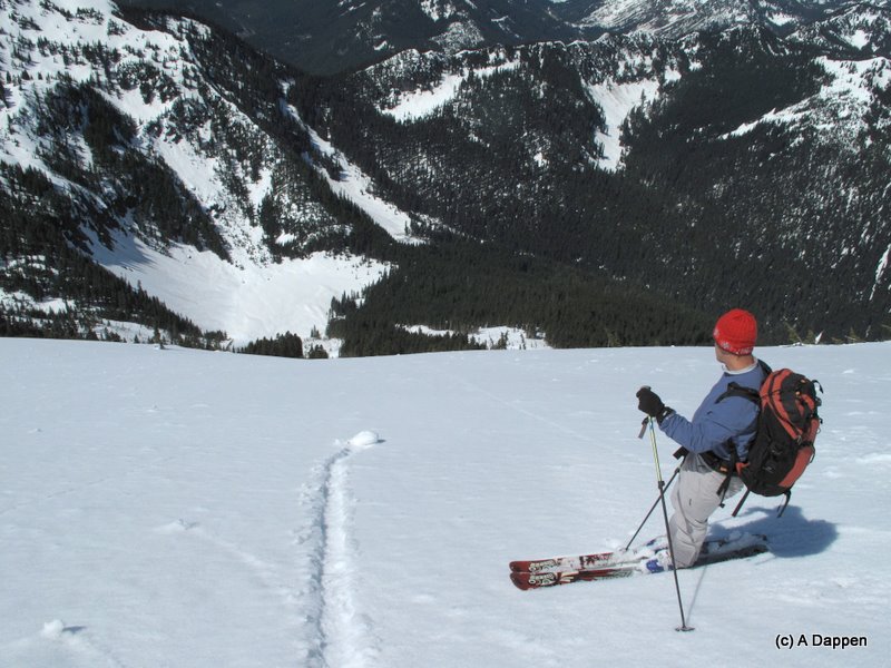
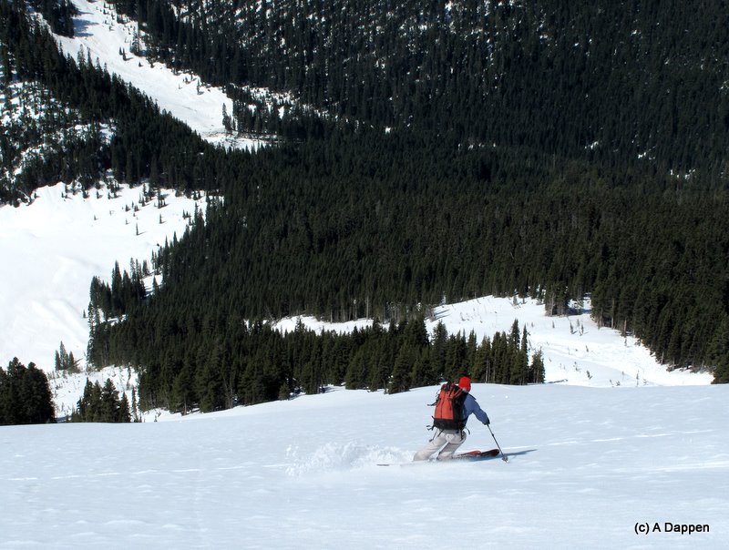
From the summit of Rock, we descend the mountains massive 3,000-vertical-foot west face lined with the gunbarrels of ten impressive avalanche swaths. Sometimes venturing onto these slopes would be an invitation to throw your molecules into the great cosmic atom scrambler, but today the snow is anchored with the armor of frozen spring snow. The surface has softened and carves beautifully by 10:30 a.m. when we ski it. This will be turning to mush later in the day, but right now the slopes are a slice of paradise and we fly down to Snowy Creek in minutes.
The forests we find in the secluded backyard of the mountain are dominated by old hemlocks, some that require two or three tree-huggers to embrace. It's here that the route-finding turns interesting. We tour up the northernmost fork of Snowy Creek to a 5,130-foot pass; contour under several rocky summits forming the spine of Nason Ridge; thread a few more passes forming low spots in the ridge; and finally find ourselves touring up the northeast ridge of Peak 5,576, which sits above the Smithbrook Road and, on our USGS maps, forms the western-most extension of Nason Ridge. All day the character of the light and the big bald peaks surrounding us to the southeast in the Chiwaukums and to northwest in the Glacier Peak Wilderness are other worldly they evoke vivid memories of spring tours in the European Alps.
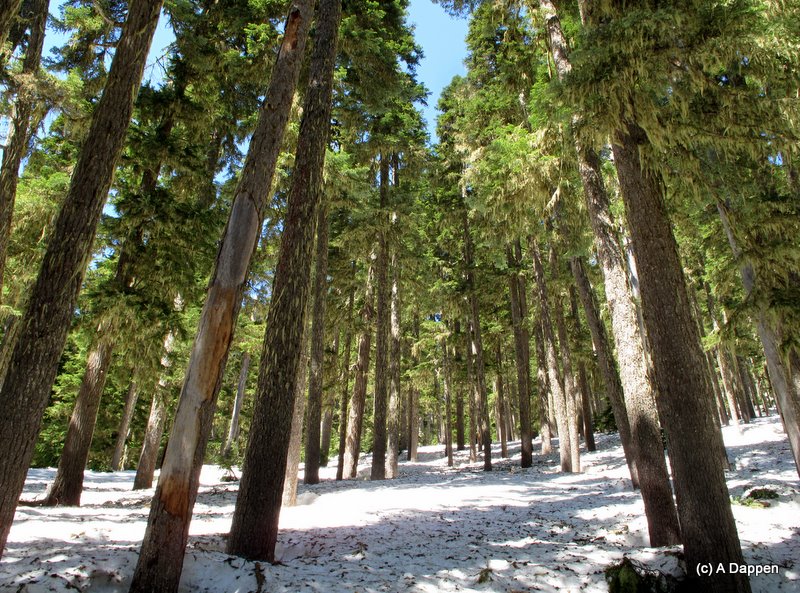
From our final peak above the Smithbrook Road, we ski downhill through old-growth forests carpeted with soft, consolidated snow that carries us all the way down to the small swithbacks in the road. The water-saturated snow is slow but tree skiing rarely gets any better. On needle-carpeted snow, we snake around the moss-covered giants of the Northwest.
We intersect the Smithbrook Road and another 1.5 miles of poling and gliding cap off the day. The snow lasts all the way to Highway 2 but as soon as we click out of the skis and step onto the dirt flanking the tarmac, glacier lilies and trillium greet us. Skiing should always be so sweet.
++++
See the WenatcheeOutdoors.org website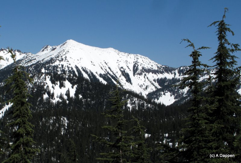
During the first weekend of June, Tom Janisch and I discover another plus -- wildflowers. Hiking up the Rock Mountain Trail is a wildflower slideshow with Indian paintbrush, serviceberry, groundsel, dwarf waterleaf, kinnikinnick, trillium, and glacier lilies lining the corridor. For those of us headed up into the monochrome world of winter, all this color is a feast.
The trail transports us quickly upward and at the 4,800-foot level we hit the Bingo Line, that spot where in one step we move from dirt to skiable snow. We follow the snowed-over trail to the summit of Rock Mountain (6,852 feet) with its spectacular views of the Cascades. The mountains from Rainier to Baker are razor sharp today. Whats not so sharp is our ability to identify them. There are perhaps 50 peaks we can identify, but with over 500 summits scraping the skyline this constitutes a pitiful batting average.
From the summit of Rock, we descend the mountains massive 3,000-vertical-foot west face lined with the gunbarrels of ten impressive avalanche swaths. Sometimes venturing onto these slopes would be an invitation to throw your molecules into the great cosmic atom scrambler, but today the snow is anchored with the armor of frozen spring snow. The surface has softened and carves beautifully by 10:30 a.m. when we ski it. This will be turning to mush later in the day, but right now the slopes are a slice of paradise and we fly down to Snowy Creek in minutes.
The forests we find in the secluded backyard of the mountain are dominated by old hemlocks, some that require two or three tree-huggers to embrace. It's here that the route-finding turns interesting. We tour up the northernmost fork of Snowy Creek to a 5,130-foot pass; contour under several rocky summits forming the spine of Nason Ridge; thread a few more passes forming low spots in the ridge; and finally find ourselves touring up the northeast ridge of Peak 5,576, which sits above the Smithbrook Road and, on our USGS maps, forms the western-most extension of Nason Ridge. All day the character of the light and the big bald peaks surrounding us to the southeast in the Chiwaukums and to northwest in the Glacier Peak Wilderness are other worldly they evoke vivid memories of spring tours in the European Alps.
From our final peak above the Smithbrook Road, we ski downhill through old-growth forests carpeted with soft, consolidated snow that carries us all the way down to the small swithbacks in the road. The water-saturated snow is slow but tree skiing rarely gets any better. On needle-carpeted snow, we snake around the moss-covered giants of the Northwest.
We intersect the Smithbrook Road and another 1.5 miles of poling and gliding cap off the day. The snow lasts all the way to Highway 2 but as soon as we click out of the skis and step onto the dirt flanking the tarmac, glacier lilies and trillium greet us. Skiing should always be so sweet.
++++
See the WenatcheeOutdoors.org website
Nice report, Andy.
Thanks.
Thanks.
Awesome report Andy! That boy's got a way with words I tell ya. It's amazing that there is so much lower snow there for this time of year.
Great report, thanks.
Man, those convex roll-overs like in the second photo always spook me a bit.
Man, those convex roll-overs like in the second photo always spook me a bit.
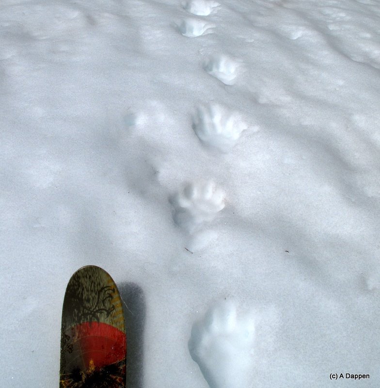
We were surprised by the low snow, too, and that we could ski Smithbrook all the way to the Highway. We were also surprised by the absence of ski tracks on the road. Given the conditions, Union Peak, Jove, and McCausland would have been good objectives (and will be good objectives for a while longer). Interestingly we saw a bear tracks in three different places along the route -- don't know if they were different animals or one intent on finding the best place to ambush the Cheetos on skis he heard would be coming.
Regarding the convexity of the slope in picture 2, it's something of an illusion. The slope is steep and has some bulge to it, but at any given point you can see a long way down. The second picture in the two additional ones posted doesn't trick the eye as much.
Regarding the convexity of the slope in picture 2, it's something of an illusion. The slope is steep and has some bulge to it, but at any given point you can see a long way down. The second picture in the two additional ones posted doesn't trick the eye as much.
author=ADappen link=topic=21072.msg90121#msg90121 date=1307482885]
Regarding the convexity of the slope in picture 2, it's something of an illusion. The slope is steep and has some bulge to it, but at any given point you can see a long way down. The second picture in the two additional ones posted doesn't trick the eye as much.
Yes, the second photo shows the line nicely. Looks about as good as it gets in spring. Great read and photos, the kind of stuff that helps me justify to my wife why I love the sport and frequent this site so often.
author=JibberD link=topic=21072.msg90162#msg90162 date=1307506876]
the kind of stuff that helps me justify to my wife why I love the sport and frequent this site so often.
It speaks well of you that your wife values having you around. More often than not I have to justify to my wife why I'm not spending at least one of the weekend days doing something outdoors. Being insufferable has its advantages.
Reply to this TR
Please login first: